SENSE webinar no 1: InSAR data and theoretical aspects

Presenters: Malte Vöge, Luke Bateseon and Joonsang Park
Norwegian Geotechnical Institute (NGI), Oslo, Norway and British Geological Survey (BGS), Nottingham, UK.
Date: Date passed (9 November 2021)
Time: 11.00 – 12.00
This is a two-part webinar:
11.00-11.05: Introduction by Bahman Bohloli, NGI
Talk 1, 11.05-11.45:
“InSAR monitoring at In Salah (Algeria) and Hatfield Moors (UK)“, presented by Malte Vöge from the Norwegian Geotechnical Institute (NGI), and Luke Bateson from the British Geological Survey (BGS).
Abstract, talk 1
InSalah
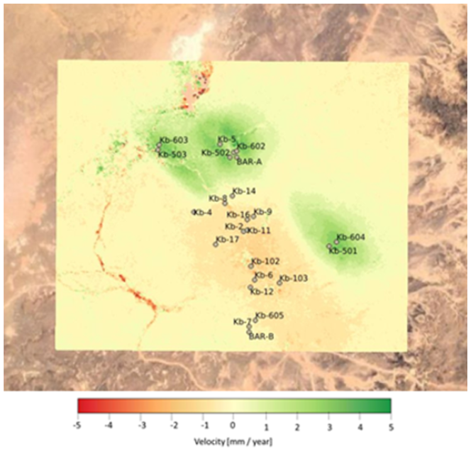
NGI will present InSAR measurements over the CO2 injection site at the InSalah oil field, Algeria, obtained by TRE Altamira. The presented dataset combines data from 3 satellites (ENVISAT, Radarsat-2 and TerraSAR-X) and in the period from 2004 to 2016, which covers injection (2004-2010) as well as post-injection (2010-2016). We will present a workflow for merging the temporally overlapping individual datasets, that results in a continuous time series datasets. The merged displacement timeseries show a clear correlation between injection activities and heave/settlement of the surface. Based on this data, volume changes in the subsurface have been estimated, which provide the basis for calibration of numerical models of the CO2 plumes.

InSAR displacement velocity map over the InSalah CO2 injection site.
Hatfield Moors
BGS will introduce Hatfield Moors as an analogue for fluid injection at onshore CO2 storage sites. Hatfield Moors is a depleted UK gas field which Scottish Power use as a natural gas storage site, with gas being routinely injected and removed to meet seasonal demand. The aim of the research is therefore to link InSAR measurements of ground motion to the gas volume changes. To aid this geological modelling of the reservoir and gas has taken place. However, there are complicating factors at Hatfield Moors; the reservoir underlies a peat lands nature reserve, meaning that the landcover is far from suitable for InSAR due to the lack of radar reflectors, secondly the superficial peat deposits will augment any ground motion as water levels change. To mitigate these limitations BGS have installed radar corner reflectors (CRs) in an attempt to guarantee measurements and to offer the ability to separate the peat based motion from that driven by gas injection activities.
We will present preliminary InSAR results for the 2015-2020 period processed using the SBAS method, these represent the period before CRs were installed with the SBAS method providing the best measurement density given the landcover. We will also present SBAS and PS InSAR data for the period when CRs were installed (December 2020 to present) and investigate links between the time series and gas injection history. Finally we will introduce the InSAR time series detector which identifies offset and gradient changes within the motion signals to highlight signals of interest.
Talk 2, 11.45-12.00:
“Generalized Geertsma solution for ground deformation” presented by Joonsang Park from the Norwegian Geotechnical Institute (NGI).
Abstract, talk 2
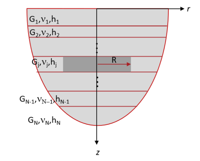
The well-known, and commonly used Geertsma solution defines the relationship between pressure in the subsurface and ground deformation. However, the Geertsma solution solves for isotropic homogenous materials, while the realistic subsurface is more complex (Figure 1).
In the SENSE project, we have developed a generalized Geertsma solution in order to overcome such limitations in the Geertsma solution.
In this webinar, we will present the generalized Geertsma solution, and discuss its usefulness in the context of CO2 storage monitoring using ground surface deformation. Additionally, we will provide a brief review on Geertsma-type analytical solutions available in the literature. We will also demonstrate how to apply the generalized Geertsma solution to realistic geological models via solving an In-Salah-like model with utilizing the linear superposition theorem.

Vertically transverse isotropic (VTI) subsurface model consisting of N layers and subjected to fluid-induced constant pore pressure p(r, z) (darker-shaded) of radius R in an n-th layer. Note r, Vs, Vst, Vp, Vpt, and h are mass density, radial/horizontal and vertical S-wave velocities, radial/horizontal and vertical P-wave velocities, and layer thickness, respectively. Axisymmetric coordinates (r, z) are used and z-positive is upwards.
SENSE is a research project funded under the ERA-NET ACT program. Its primary objective is to demonstrate reliable, cost efficient CO2 storage monitoring using ground surface deformation detection combined with geomechanical modelling and inversion to provide information on pressure distribution and hydraulic behaviour of storage sites. For this purpose, it is crucial to apply an efficient solution to link surface deformation directly and accurately to the fluid pressure change and hydro-mechanical properties in the subsurface.